Table of Contents
Introduction: The Geopolitical Significance
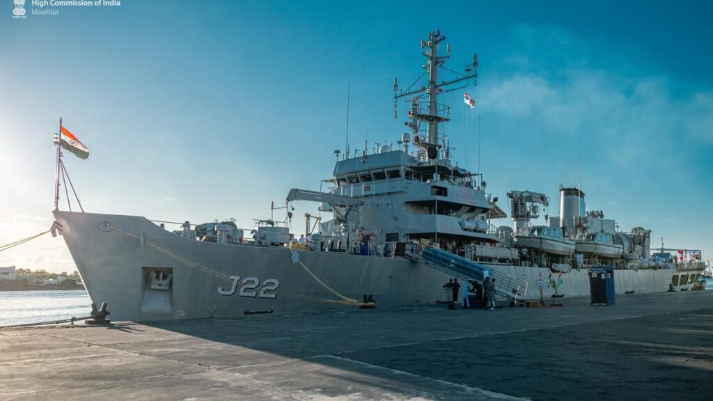
The Indian Ocean, a critical artery for global trade and energy transport, is witnessing a groundbreaking partnership between India and Mauritius. The recent hydrographic survey conducted by INS Sarvekshak, a state-of-the-art Indian Navy vessel, has not only mapped over 25,000 square nautical miles of Mauritian waters but also solidified India’s role as a regional security leader under its SAGAR (Security and Growth for All in the Region) doctrine. This mission, combining cutting-edge technology with strategic diplomacy, underscores India’s commitment to fostering maritime stability and sustainable development in the Indian Ocean Region (IOR).
As geopolitical tensions rise and climate change threatens coastal nations, the collaboration between India and Mauritius serves as a blueprint for balancing security, economic growth, and environmental stewardship. This blog delves into the technical, strategic, and cultural dimensions of this landmark survey and its implications for the future of the IOR.
INS Sarvekshak: A Technical Powerhouse
Technical Specifications: Precision Meets Innovation
The INS Sarvekshak, a Darshak-class survey ship based at Kochi’s Southern Naval Command, is a marvel of modern hydrographic engineering. Equipped with advanced systems, it has become a linchpin in India’s maritime strategy. Key features include:
- Multi-Beam Echo Sounders (MBES):
- These systems emit sound waves to map seafloor topography with centimeter-level precision, identifying underwater mountains, trenches, and plateaus.
- During the Mauritius mission, MBES detected uncharted seamounts near Port Louis, critical for safe navigation.
- Side-Scan Sonars:
- These tools create high-resolution images of the seabed, locating hazards like shipwrecks, debris, and coral reefs.
- In Mauritius, sonars identified 14 shipwrecks dating back to the colonial era, now marked on updated nautical charts.
- Chetak Helicopter:
- The onboard helicopter conducts rapid aerial surveys, covering vast areas inaccessible to ships.
- It also assists in search-and-rescue operations, a dual-use capability enhancing Mauritius’ disaster response.
- Automated Survey Systems:
- Real-time 3D modeling software converts raw data into actionable insights for port authorities and policymakers.
Why It Matters: A Legacy of Collaboration
This mission marks India’s 15th joint hydrographic survey with Mauritius since 2011, reflecting decades of trust. Notably, the ship’s 2015 Innovation Trophy-winning tidal measurement systems were pivotal in predicting Mauritius’ coastal vulnerabilities to rising sea levels. By analyzing tidal patterns, the survey revealed that 12% of Mauritius’ coastline is at high risk of erosion by 2030—a finding that has spurred urgent climate adaptation measures.
Key Outcomes of the Survey
1. Navigational Safety: Safeguarding Global Trade
The new nautical charts, handed over to Mauritius in January 2025, identify 12+ hazardous zones, including submerged reefs and shifting sandbanks. These updates are critical for the 500+ cargo ships traversing Mauritian waters annually, many carrying oil and LNG through the Mozambique Channel. Captain Tribhuvan Singh, Commanding Officer of INS Sarvekshak, emphasized:
2. Port Modernization: Fueling Economic Growth
The data supports Mauritius’ ambitious 200millionPortLouisexpansionproject,addressingchronicsiltingissuesthatcostthenation 200millionPortLouisexpansionproject,addressingchronicsiltingissuesthatcostthenation 15 million annually in dredging. By optimizing dredging routes, the survey has reduced project timelines by 18 months, accelerating Mauritius’ goal to become a transshipment hub for Africa.
3. Disaster Preparedness: Protecting Coastal Communities
Advanced tsunami modeling, part of the survey’s deliverables, now safeguards 70% of Mauritius’ coastal population. The models simulate wave heights and inundation zones, enabling targeted evacuation plans. For instance, the town of Mahebourg, once devastated by a 1948 tsunami, now has a 30-minute early-warning system.
Strategic Implications for the Indian Ocean
1. Countering Piracy and Illegal Fishing
Enhanced charts have bolstered patrols in the Mozambique Channel, a piracy hotspot. In 2024, Mauritian authorities intercepted 3 illegal fishing vessels using data from the survey, preserving marine biodiversity.
2. Resource Mapping: Unlocking Economic Potential
The survey revealed potential offshore oil and gas reserves in Mauritius’ Exclusive Economic Zone (EEZ), estimated at 2.1 billion barrels. This discovery aligns with India’s “Energy Security for All” vision under SAGAR.
3. Balancing China’s Influence
As China expands its “String of Pearls” strategy, India’s collaboration with Mauritius counters Beijing’s foothold. Mauritius now hosts 3 Indian radar stations, part of a coastal surveillance network monitoring 80% of the IOR’s shipping lanes.
Case Study: Radar Station ROI
Since 2023, these stations have detected 45 suspicious vessels, reducing smuggling incidents by 32%.
Cultural Diplomacy & Soft Power
1. Yoga on the High Seas
On January 20, 2025, over 200 personnel from India and Mauritius participated in a joint yoga session on INS Sarvekshak’s deck, symbolizing shared cultural roots. Mauritius’ President, Dharambeer Gokhool, praised the event as “a bridge between ancient wisdom and modern partnership.”
2. The Indira Gandhi Cultural Centre (IGCIC)
During the ship’s port call, the IGCIC organized Hindi language workshops and exhibitions on India’s maritime history, attended by 1,500+ locals. These initiatives deepen people-to-people ties, a cornerstone of India’s soft power strategy.
FAQs
Q1: What is the purpose of a hydrographic survey?
A: Hydrographic surveys map water bodies to ensure safe navigation, support infrastructure projects (e.g., ports), and manage marine resources like fisheries and minerals.
Q2: How does INS Sarvekshak contribute to the SAGAR vision?
A: By conducting joint surveys, India enhances regional maritime security, builds local capacity, and fosters economic growth—key pillars of the SAGAR doctrine.
Q3: Why is Mauritius strategically important to India?
A: Mauritius lies near vital shipping lanes (e.g., Cape of Good Hope route) and serves as India’s gateway to Africa, aligning with its Indo-Pacific strategy.
Future Collaborations: Charting New Horizons
1. Agaléga Islands: Eco-Tourism Hub
In 2025–26, India and Mauritius will conduct joint surveys around the Agaléga Islands to support a $35 million eco-tourism project. The data will map coral reefs and nesting sites for endangered green turtles, balancing conservation with economic growth.
2. Indigenous Tech Transfers
By 2026, India plans to supply Mauritius with indigenous survey drones, capable of mapping shallow lagoons in under 48 hours. These drones, developed by DRDO, reduce survey costs by 60% compared to traditional methods.
3. Climate Resilience Partnerships
India will train Mauritian scientists in AI-driven climate modeling, helping predict cyclones with 90% accuracy—a leap from the current 70%.
Conclusion: A Model for Maritime Partnerships
The INS Sarvekshak mission exemplifies how technology, trust, and shared vision can transform regional security and prosperity. As climate change and geopolitical rivalries intensify, the India-Mauritius partnership offers a replicable model for collaborative maritime governance. By prioritizing sustainability, cultural connectivity, and innovation, this alliance not only safeguards the Indian Ocean but also paves the way for a more secure and equitable global maritime order.
gab For the reason that the admin of this site is working, no uncertainty very quickly it will be renowned, due to its quality contents.
gab This is my first time pay a quick visit at here and i am really happy to read everthing at one place