Why in News?
- Today, due to the emergence of new environmental problems in the course of climate change, international cooperation is vital to solve emerging challenges.
- One such revolutionary activities is the NASA-ISRO Synthetic Aperture Radar (NISAR) that is a collaborative mission of United States of America and India.
- This partnership was marked by a visit of the US National Security Advisor Jake Sullivan to New Delhi where India and the United States have manifested the spirit of cooperation.
The Significance of US-India Space Collaboration
- The sending of NASA-ISRO Synthetic Aperture Radar in partnership with NASA and the Indian Space Research Organisation or ISRO is a positive sign for space cooperation.
- The world’s two largest democracies, the United States, and India have had diplomatic relations since the early 20th century and cooperate on many levels ranging from defense to trade and technology.
- Through its affirmation of this partnership in space exploration and environmental surveillance, their friendship becomes deeper, and relations between nations akin to this become enhanced.
- The announcement comes at the event of a new era for collaboration between the US Space Force and Indian young tech firms, 114ai and 3rdiTech.
- This partnership is to enhance concern in SSA, data fusion, and infrared sensor semiconductor producers.
- It is significant to note that these efforts not only help to strengthen ST to space technology but also contribute to bolstering both countries’ strategic capacities for addressing global issues.
Understanding NASA-ISRO Synthetic Aperture Radar
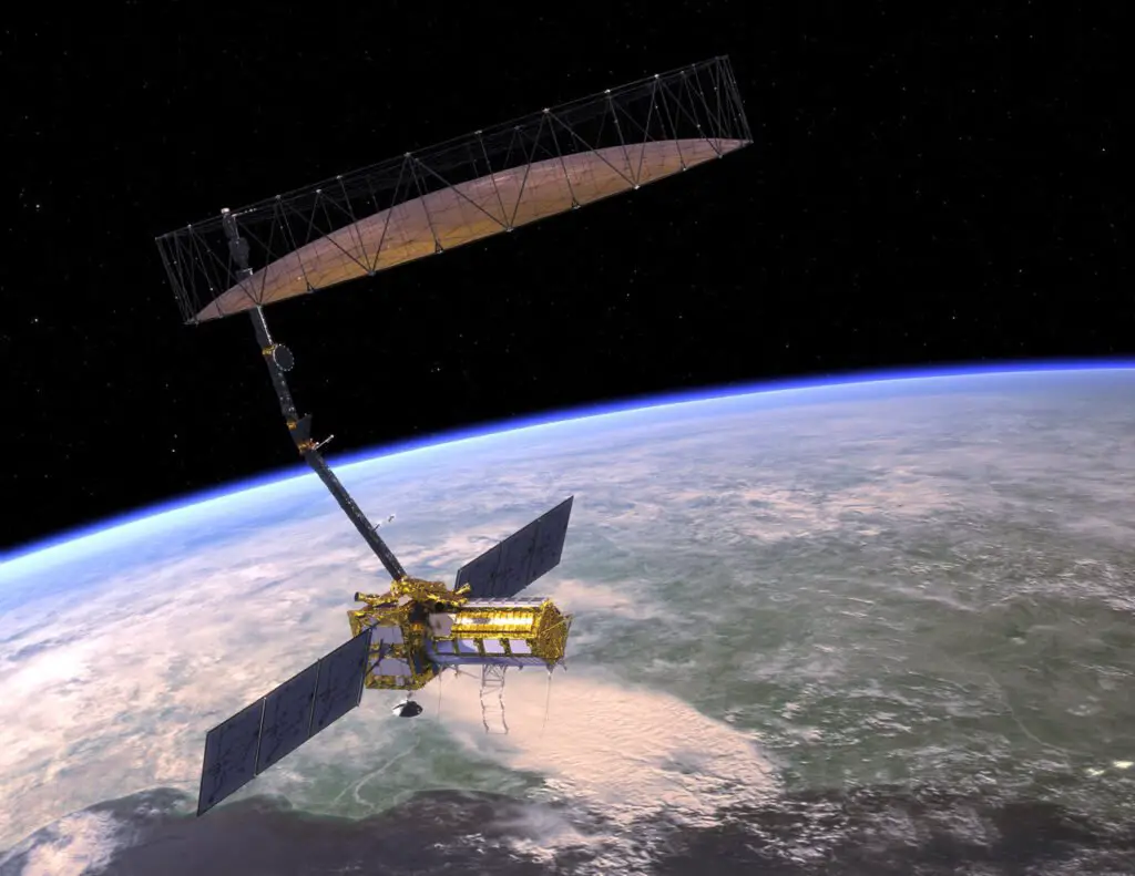
- NASA-ISRO Synthetic Aperture Radar is an earth observing satellite that will be built and operated through equal collaboration between NASA and ISRO.
- This mission is path breaking mission in space technology and the first time that both agencies have worked together on common hardware for an Earth observing mission.
- The satellite holds elaborate synthetic aperture radar systems, which own the capability to gather clear explains of the surface of the earth at any time of the year in any type of weather.
Dual-Band Radar System
- This is precisely one of the most innovative aspects of NISAR which will carry an L-band synthetic aperture radar and an S-band synthetic aperture radar.
- Together, it makes it possible for NISAR to view a nearly infinite number of environmental events to an astonishing degree of specificity.
- The L band radar is highly useful for travelling through vegetation and soil, for this reason it is ideal for use on forests, wetlands and farming land.
- On the other hand, S-band radar measures variation changes in the surface which are as a result of earthquakes and volcanic activities.
Global Monitoring Capabilities
- Due to the capability of the NISAR to acquire precise measurements of surface changes of the Earth, it is a useful instrument in the study of climate change.
- This satellite can monitor changes in the ice fields and glaciers besides the shifting of tectonic planes and the disasters like floods and landslides.
- NISAR helps assess various environmental processes and shape climate change mitigation solutions because it provides nearly real-time data.
Launch and Operational Plans
- NISAR satellite is planned to be launched from the Satish Dhawan Space Centre located on the southeastern coast of India.
- Currently, it is reported that the construction of the spacecraft is almost complete and the launch readiness date is planned to be said by the end of April.
- This is a major accomplishment in the mission as evident by NASA and ISRO’s teamwork full encapsulated by technical prowess.
- After being placed in orbit NISAR will start its work of capturing high-quality images of the earth’s surface.
- The data that will be gathered by the satellite will be relayed to the earth stations and then disseminated to researchers, policy makers, and such other environmental organizations/ agencies of the world.
- This open-access approach will enable all the challenges that will be revealed by NISAR can be solved with the insight resulting from this research.
Addressing Climate Change
- Climate change continues to be one of the biggest global challenges affecting various aspects of human life, the earth’s biosphere and the economy.
- This is particularly significant to the NASA-ISRO Synthetic Aperture Radar mission because of the involvement in increasing knowledge of climate occurrences and contributing to the effort to reduce their impact.
Supervising Ice Sheets And Glaciers
- This is important since monitoring of changes in ice sheets and glaciers is one of the focal area’s of NISAR.
- Polar ice is also melting at a really fast rate as the global temperatures continue to rise, this causes the sea level to rise and affect the circulation of water in oceans.
- Owing to the fact that, NISAR can detect the minute changes in the elevate profiles and melting pattern of these ice masses at very high resolutions.
- Hence, this information is important for future sea level prediction and planning for protection of coasts which are sensitive to such changes.
Observing Forests and Wetlands
- Formerly, these areas include forests and wetlands have specific CO2 absorbing significance for climate behavior and species life. L-band radar feature of NISAR is equally useful in tracking forest cover and demographic variations within a specific area.
- This capability enables the researchers to evaluate the health status of the forests, find where the most deforestation is occurring and help in the conservation of the forests.
- At the same time, using NISAR to peer through vegetation is important for the investigation of wetlands needed in the purification of water as well as prevention of floods.
Assessing Geological Activity
- Besides, given that NASA-ISRO Synthetic Aperture Radar is capable of identifying alterations in Earth’s surface, the device may also be used for geophysical investigation.
- It can also note variations in the earth surface due to earthquakes, volcanic eruptions, and landslides which will be helpful in instances of disaster management.
- Such natural hazards in turn, NISAR helps in establishing earliest signs for any catastrophes and helps in plans to reduce the human endure able losses from these calamities.
Enhancing Global Security
- Besides the valuable addition to the climate science, the NISAR mission also helps in increasing global security by offering vital information for multiplying its uses.
- The radar images that the satellite will provide at a high resolution can also aid in activities concerning farming, water usage and control, and city development.
- For instance, NISAR can assist in early detection of disease and pests in crops, measures the water required to the crops, know the effects of urbanization on the natural environment.
Supporting Strategic Partnerships
- Thus, the goals of NASA-ISRO Synthetic Aperture Radar mission are in tune with other strategic bilateral cooperation between USA and India.
- Through mutual cooperation on space technology, both countries improve their capacities in solving common problems.
- It is for this reason that relying on the US Space Force’s partnership with two Indian startups, 114ai and 3rdiTech, it is clear that the US continues to further this culture of new-age development.
Conclusion
- NISAR which stands for NASA-ISRO Synthetic Aperture Radar signifies a massive collaboration between two space agencies of two countries and vast improvements to environmental monitoring systems.
- In addition to fortifying the relations upon defense and security of the two countries, it is a worthy mission to understand more about climate change and global security.
- At the moment when NISAR is going to map Earth’s surface with the level of detail incredible, it is noteworthy that the effective approach to many of the problems of the epoch requires international collaboration.
- NISAR that combines state-of-the-art radar systems with public datasets could revolutionise the study of environment and contribute to fight climate change’s effects.
- It is a clear demonstration that cooperation should be the direction of any successful effort to drive scientific discovery and achieve a better world for everyone.
FAQS
Q1: What is the NISAR mission?
Ans: NASA is going for the Synthetic Aperture Radar mission, signed jointly with the Indian Space Research Organisation (ISRO) known as NISAR. It seeks to track shifts in the planet’s skin or surface like movements of ice sheets, variations in forest cover, and earth’s movements using RADAR.
Q2: How NISAR radar technology is going to function?
Ans: NASA-ISRO Synthetic Aperture Radar employs a dual band synthetic aperture radar system, of L band and S band. This technology allows the satellite to photograph the surface of the earth irrespective of weather or time of the day. The L band radar works through the vegetation and soil while the S-band radar addresses surface alterations of a smaller scale.
Q3: In what ways does NISAR support climate change study?
Ans: NASA-ISRO Synthetic Aperture Radar is useful in precise measurement of other changes in the environment such as meltings metabolites, deforestation, land deformation among others. This data is vital in
Thank you for your sharing. I am worried that I lack creative ideas. It is your article that makes me full of hope. Thank you. But, I have a question, can you help me?